Two Weeks Up The Staffs & Worcs

Wilden To Wolverley

Sunday, twenty-second September, was as wet and miserable as forecast so we stayed put, as planned. Monday did not seem much better and we debated whether to move at all. In the end, we convinced ourselves that we could see a break in the rain and set off about ten-thirty. At the first lock we caught twenty minutes of heavy rain but after that, while it was hardly pleasant, we only encountered a few light showers.

We had a busy day planned, stopping in Kidderminster first for water, then to collect Amazon parcels and visit M&S and another stop above the lock and the church to get the weekly shopping at Sainsbury's.  By the time we had finished there it was half past three but we did want to move out of Kidderminster and the sky had, at last, cleared so we put in another forty-five minutes to get through Wolverley Court Lock and moor up in a nice, open spot just above it.

Our whole route back from Wilden would be on canals we have travelled before which, perhaps, explains why we took so few photographs. We did spot this great carving on our way north from Kidderminster to Wolverley.

En Route To Wolverley In A Little Afternoon Sunshine

Kinver

On Tuesday, twenty-fourth September we moved on up to Kinver. A better day, dry and fairly fine, with less than two hours cruising. Straightforward, for the most part, other than the hire boat "Bright Star" pulling out just ahead of us and crawling up to the first lock. We kept well back but when we got up there, we found the reason that they weren't making much progress in emptying the lock. The paddles they had opened were at the top end! Once we sorted that out they did let us go out first, so we were able to make better time.

We moored up a little short of Kinver Lock, at Whittington Horse Bridge. It was more open there and we could see a mobile phone mast up on the opposite hillside. We had a good signal from O2 but nothing from EE. However, we did see a couple of hard hatted figures moving around the mast site and a loose cable dangling down. Later in the afternoon we suddenly had a really excellent EE signal and assumed they must have fixed something. Sadly, it didn't last and we were back to zero by the following lunchtime.

We went up into Kinver on Wednesday and had a look round. It always seems quite a well-to-do area but we noted a lot of businesses were closed, some for half day closing but a lot permanently out of business. Fortunately, the place we remembered, Café No.5, was still open, in the mews off the High Street, so we managed to get a nice lunch there. Then we headed back to the boat and started sorting out fuel supplies so that we would be ready to light the stove and keep it going, if that became necessary.

Greensforge & Bratch Locks

On Thursday, twenty-sixth September, we got going unusually early, for us, at about nine o'clock. This worked out well, in the end, as we left under a fairly bright sky and got through Kinver Lock and up to the services above before half an hour of thin drizzle swept over us. Since we were mostly inside, dealing with the water tank etcetera, that didn't matter and by the time we were moving again it was dry with some very nice, sunny spells. We were moored up, just before Greensforge Lock, by half-past twelve, well before some heavier rain, followed by a couple of significant thunderstorms, arrived in the afternoon.

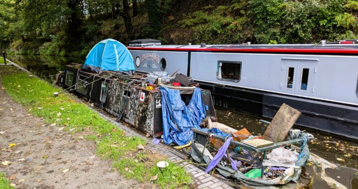
It was a long night of heavy rain until about eight-thirty the next morning. We stayed where we were while we did the washing so that we could fill the water tank again at the water point above Greensforge Lock. We finally set out at about ten-thirty up through the lock and moored at the water point just past this sad sight.

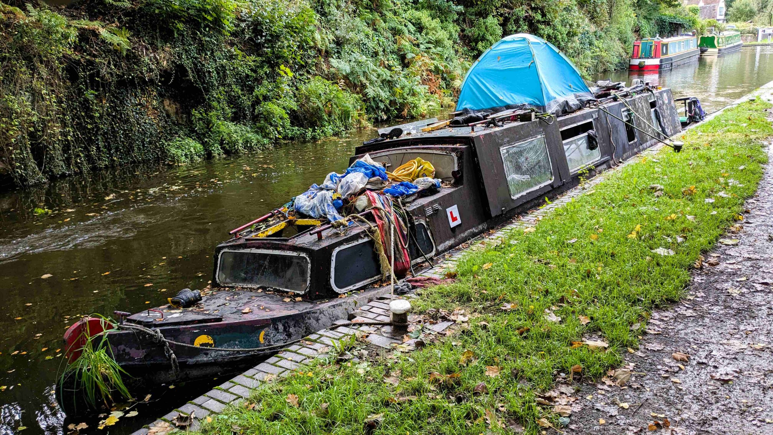
Sunken Hulk At Greensforge Lock

Someone told us that this had been there for months and had even been re-floated a couple of times. Originally, it was below the lock but was somehow brought back up, came up through the lock and then sank again, here at the top. Presumably, some bodged repair was simply inadequate and failed immediately. Someone had, apparently, been living in the tent but they were not there any more and no-one knew what would happen with it next.

We moved towards Wombourne and stopped there, by the bridge, which is a few hundred yards from Sainsbury's. The weather was improving but a cold north wind was also steadily strengthening and by the time we had the shopping back on board it was quite fierce. However, the sun was now shining brightly so we carried on.

We were only about a mile from Bratch Locks. Originally built as a three part staircase these were soon found to use too much water. They were rebuilt as three separate locks but with very short pounds, just a few feet, between them and supported by side ponds. They have brightly painted paddle gear in blue and red and some complicated directions on how to operate them, with which colour first. Happily, we didn't have to worry about working that out as there were three CRT volunteers on site to direct us and help us through.

Just beyond the locks is a visitor mooring, with rings and a nice firm towpath, views across open fields to the sunset and no-one else moored there at all. We were tied up there by three o'clock and I had time to take Archie out for a walk. There were some good paths around and you could pick out tracks that might be less affected by flooding and thick mud than others.

The Monarch's Way was a great help here, as it complemented the quite well-surfaced towpath by running more or less parallel to it, about half a mile away. This is a long-distance path that, more or less, traces the route taken by Charles II to escape Cromwell's forces following Charles' defeat in the final battle of the English Civil War, at Worcester, in sixteen fifty-one. It covers a lot of ground, six hundred and twenty-five miles, from Worcester, via Wolverhampton, to the Dorset coast and then across to Shoreham in Sussex.

The convoluted route suggests there was quite a lot of ducking and diving involved in this escape!

We didn't have time to do the whole trail that afternoon but followed it for about a mile, where it uses a disused railway track. This section is obviously well used as we came across "the platform" a café stop for hikers and cyclists half way along.

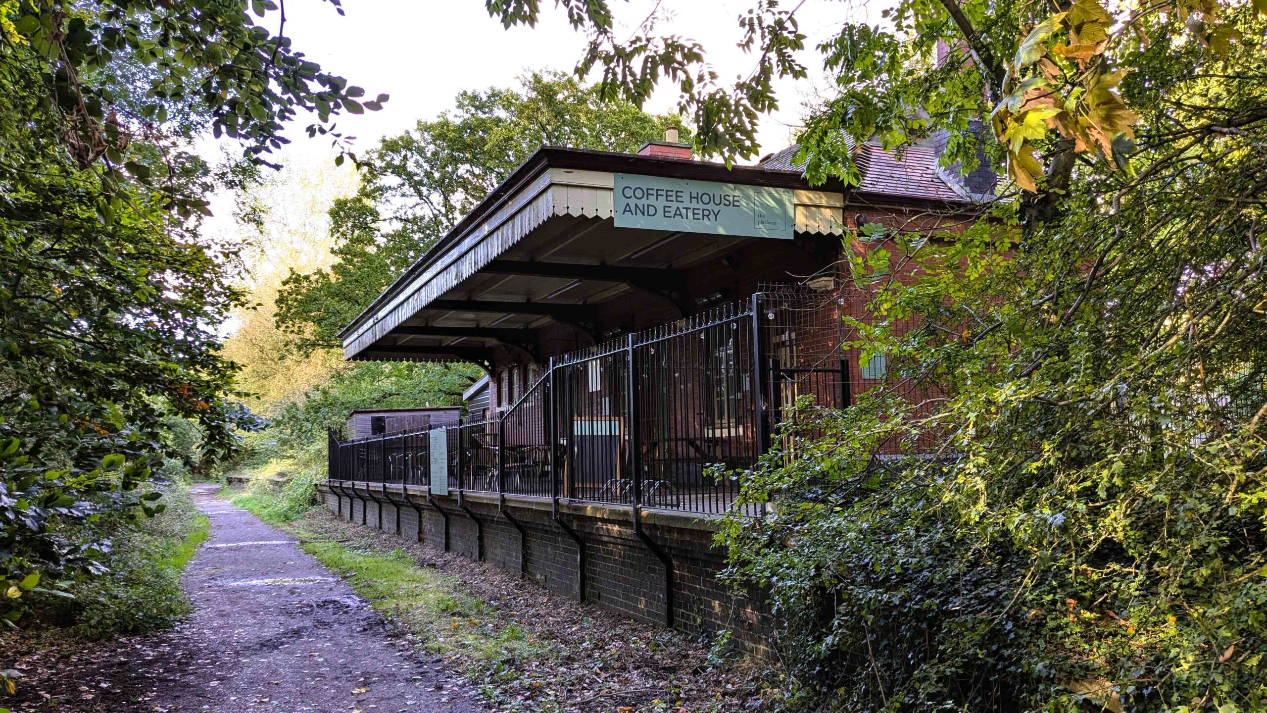
"the platform" On The Monarch's Way

Wightwick To Coven

Saturday, twenty-eighth September, was a fairly fine day but with a sharp edge to the wind. We had quite a short cruise up to moor up before Wightwick Bridge by midday. Beyond here it began to look more built-up for quite a distance so it seemed a good point to stop. We had a good walk up to the next place at Compton and came back along another cycle trail created on a disused railway track. Most of the area between the track and the canal, forming a large triangle, seemed to be given over to the Smestow Valley Nature Park, some of it wetland but with good paths through it for people to wander round. Along the towpath were some good examples of the circular lock weirs that seem to be a particular feature of this early canal.

In the afternoon we went up to Wightwick Manor, a National Trust site just up from the bridge and across the main road. We had a wander round the gardens there and collected some cake for tea.

On Sunday we had planned a longer cruise to get us past the junction for Wolverhampton to the east and then the one onto the Shropshire Union to the west and ultimately, back out of the worst built-up areas. The distance was about six miles with only three locks on the way but we also planned to stop at Oxley Marine to take on fuel. We managed to get going, after a brief shower of rain, a little before ten o'clock and we worked through the first two locks by ten fifteen to head up to the last one, Compton Lock. As we approached Compton Bridge, a short distance before the lock, "Don't Tell Them Your Name" was just preparing to set off. He obviously now had to wait but he didn't seem too perturbed and I checked that he was definitely heading up through the lock.

A section of towpath for about a mile from Compton Bridge was being resurfaced. There were notices, sturdy fences and a simple diversion in place but we watched a group of young teenage runners being led by their elders and betters to heave back the fences and carry on up the towpath regardless, only to then return ten minutes later. Not setting a great example, other than one of modern-day entitlement.

We know, from our own experience, how irritating it is when you are just about to push off and another boat comes steaming round the corner so, before we left the top of the lock we went back and opened the bottom paddles for the boat we knew was following behind.

From Compton there is a ten mile lockless stretch all the way to Gailey. We passed Aldersley Junction, where the twenty-one lock flight up to Wolverhampton begins and pulled in to the wharf at Oxley Marine. We have been here a couple of times before, a classic broken-down looking, boatyard, with absolutely no frills. We moored up partly against the bank but with the bow up against the boat moored ahead. The wharfinger appeared and agreed we could get water while we were filling the fuel tank. We took on eighty litres of diesel, no nonsense with splits for VAT, cash only and a pound a litre - a real bargain. We were still filling the water tank when "Don't Tell Them Your Name" arrived, also wanting diesel. They came alongside and we tied them on while they filled up. We had a chat with the owners, Andy and Heather, ending in agreeing to meet up later that afternoon at the Anchor Inn in Coven, where we both intended to stop for the night.

Once they were filled up and untied we followed them along the canal past Autherley Junction, where the Shropshire Union Canal heads off towards Ellesmere Port and were moored up at Coven by half-past one. I took Archie for a walk around Coven Heath and back down the towpath before going up to the pub at half-past five. We had an entertaining conversation over a couple of pints and we, of course, had to ask if Andy had named the boat himself. Sure enough, he confessed he was a dyed in the wool Dad's Army fan and had chosen the name in tribute to one of their most well-known lines. They had had the boat for a while and kept it up around the South Yorkshire navigations, where we had spent a good chunk of time two years before. It was a wide beam so they had some limitations on where to take it and wanted a change so they were just about to moor it up for the winter in Hatherton Marina, a half mile or so further up the cut.

Nights were drawing in and returning to the boat, already in the dark, a little after seven o'clock and then lit the stove for the first time since we left Banbury at the beginning of May.

Gailey & Penkridge

Sunday night saw high winds and heavy rain, with the promise of more to come. We had intended to move up to Gailey on Monday, thirtieth September. It was a five mile, lockless cruise so, after a bit of debate over the forecast we decided to press on and try to get there before the rain came in again. We were largely successful, arriving in Gailey just as it started spitting. We could see the first moving boat of the day coming towards us but very slowly and saw that they were edging their way past the part-submerged canopy of a large fallen tree. They did make it through, between the branches and the far bank, so we proceeded very cautiously and got past, without any issues, to moor up just by the section of towpath reserved for the Gailey Canoeing Club. To their credit, CRT already had workers on site to assess the work required to remove the tree, which had only blown down overnight, along with many others in the region.

By the time we moored up, the rain was settling in to a persistent fine drizzle that continued through the rest of the day. Rain continued overnight becoming very heavy around seven-thirty in the morning and then, in defiance of the weather forecast, continued in various degrees of light and heavy precipitation until about four o'clock. We could see on the rainfall radar that we were sat on the very edge of a slow-moving low pressure system moving over us. It was no consolation to know that, if we were just a mile or two to the west, we would have been enjoying a fine day. As the rain stopped, the traffic picked up, so clearly there were quite a few people who had been waiting it out all day. For our part, we had no pressing reason to start moving at this time of day and could wait to see what tomorrow would bring.

It brought an overcast sky but was much brighter-looking and mainly dry. We wanted to visit Penkridge market, which is held every Wednesday and Saturday. It was two and a half miles to get to Penkridge but we also had five locks to get through so we were on the way by nine-thirty. Even with a half hour stop at the service point, we were moored up by Filance Bridge in less than three hours.

The market is located about a mile from the canal so we made our way straight up there and found it still in full swing. There are dozens of stalls, of all kinds, both under cover and outside, across a wide area. By now the sun had come out for a fine, mild afternoon and it was bustling with people coming and going. This was in stark contrast to markets we have seen in many other towns, which seem to consist of a meagre half dozen stalls and are all packed away by midday.

In the evening I went up to the nearest pub, the Cross Keys, for a drink before dinner. A very traditional pub indeed. Despite the various merchandising items advertising other brands, only Carling was available and you needed to bring your own wi-fi. There was absolutely nothing welcoming about it and the furniture scattered randomly about its three large, linoleum-floored bars was strictly designed for village halls and working men's clubs.

Stafford & Rugeley

Thursday morning brought us a much brighter but colder start, down to zero degrees by morning. We left about ten o'clock, as the day began to warm up a little and had a very pleasant four hour cruise in the sunshine. The canal leaves Penkridge and runs close to the M6 for a while, until you reach the delightfully named Acton Trussell.

The motorway veers to the north west to skirt Stafford on one side while the canal passes the town to the south east, following the River Penk. Once past the very affluent-looking Stafford Boat Club, it begins a long hairpin loop around the built-up Stafford suburbs of Wildwood, Weeping Cross and Baswich, before the land opens out to the north, with a steep escarpment to the south. We moored up here for the night with sunshine for the solar all afternoon and an excellent mobile signal.

There was no passing up the chance to visit Walton-On-The-Hill, perched at the highest point of the hill above us. Despite the steep climb it was a nice walk and the village was charming and beautifully kept, with great views from the hilltop. A sign near the centre showed a map of the village with various points of interest.

Map of Walton-On-The-Hill, Staffordshire

Most of the historic buildings had been restored and the church of St. Lawrence was particularly distinctive with its unusual white spire.  It was certainly quieter than its namesake near Tadworth.

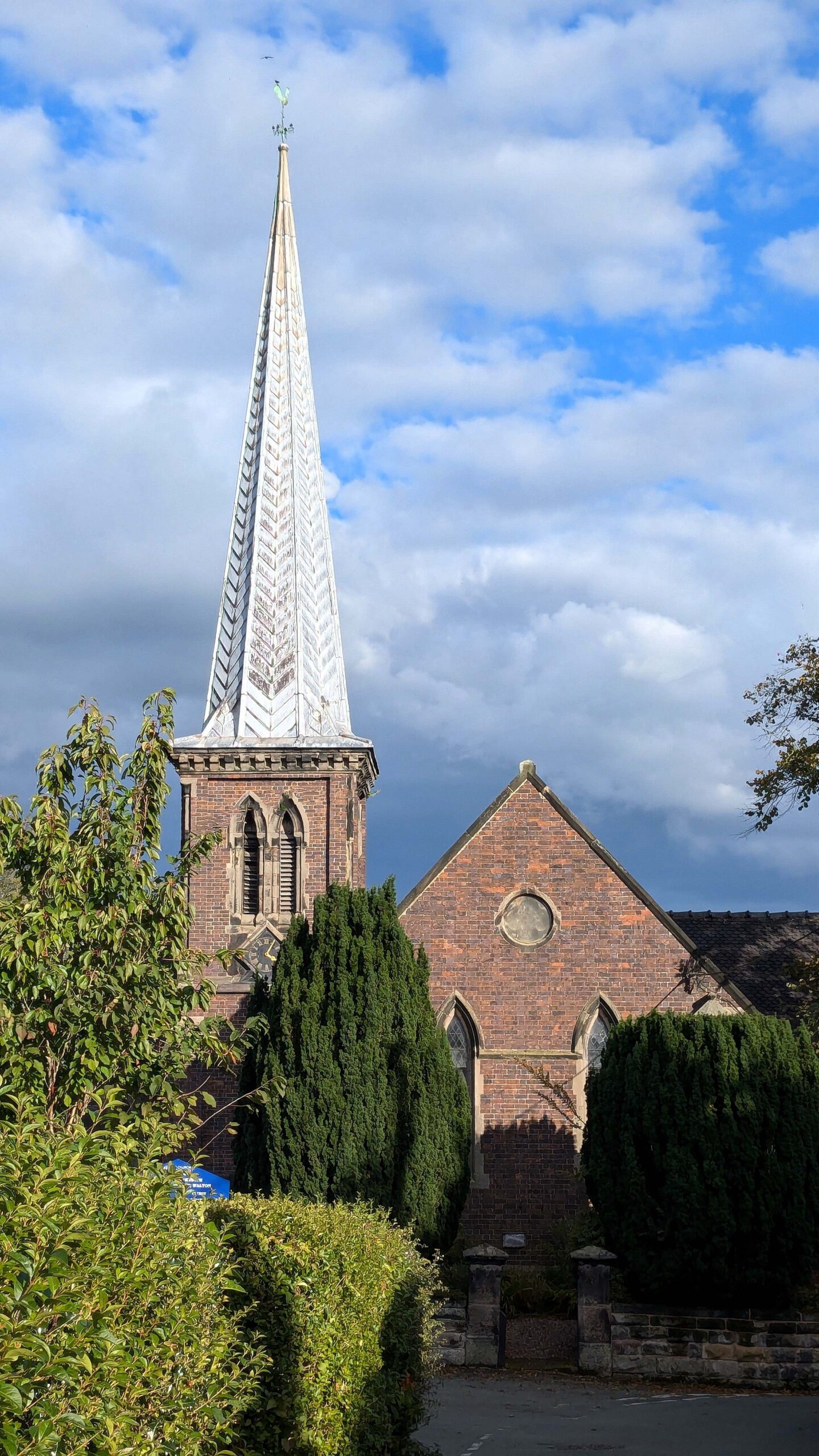
St. Lawrence Church, Walton-On-The-Hill

Friday morning, fourth October started out very foggy but it soon burned off for another fine, sunny day. We set off around nine-thirty for the final three miles to Great Haywood junction and the end of the Staffordshire & Worcestershire Canal. A boat had passed us half an hour or so before we left, so we were rather surprised to find that we were catching up with it before we reached the end. This almost never happens, given the speed at which we all travel but we slowed right down and followed them from Tixall Wide to the junction.

As we came out onto the Trent & Mersey Canal, we needed to get onto the water point to the left. Since we would be heading off to the right afterwards, it made sense to turn right and then reverse up. It is a really busy area but we managed to back up most of the way, in reasonably good order, before a boat came down behind us. There was a CRT ambassador standing by the water point, there to talk to passers-by and promote the canals, and he took a line and pulled us in the last few feet, which was a great help.

Having made use of all the services available, we set off down the Trent & Mersey, heading south, towards Rugeley. This stretch takes you past Shugborough Hall, with its broad estate park and The Wolseley Centre, a nature reserve, which keeps you nicely away from the main roads. We immediately felt there was a noticeable increase in boat traffic, in both directions, on this canal.

After three miles or so we came to the sharp dogleg that sets you on the run-in to Rugeley Town, no longer recognisable by its cooling towers, which have been demolished now, but still the home of two supermarkets, either side of the canal and a useful laundrette quite close at hand. Finding ourselves in a town on a Friday night was a good chance to fetch fish & chips from an actual chip shop, as a special treat.

Posted in Uncategorised.

Leave a Reply

Your email address will not be published. Required fields are marked *